Coromandel River and Rain Gauge Time Series
This dataset contains ten-year historical river and rain gauge measurements from the Coromandel region. These measurements being water stage values recorded from the Tairua, Opitonui and Kauaeranga ri...
Waikato Regional Council
Creative Commons Attribution 4.0 International
Lightning Strikes
Archive of lightning records and live feed for Oceania area. Spanning February 2004 to the present day.
MetraWeather Australia
Creative Commons Attribution 4.0 International

Images of Wildlife from Cameras
The WCS training set contains 217,959 images from 441 locations, and the WCS test set contains 62,894 images from 111 locations. These 552 locations are spread across the globe. [iNaturalist 2017](ht...
N/A
Creative Commons Attribution 4.0 International
Dataset order latest
Latest updates for Datasets
Open
Community Data License Agreement – Sharing – Version 1.0

LILA Wellington Camera Trap
This data set contains 270,450 images from 187 camera locations in Wellington, New Zealand. The cameras (Bushnell 119537, 119476, and 119436) recorded sequences of three images when triggered. Each se...
-
Creative Commons Attribution 4.0 International
Himawari 8 Weather Satellite
The Himawari-8 weather satellite is owned and operated by the Japan Meteorological Agency (JMA) and provides data covering: East Asia, and includes the West and central Pacific regions.
Japan Meteorological Agency
Creative Commons Attribution 4.0 International
Bay of Plenty Water Quality and Discharge Data
Collection of data sources reporting on Water quality and Discharge rates within the Bay of Plenty region.
Bay of Plenty Regional Council
Non-standard
Aggregated wave and atmospheric forecast derived from GFS guidance
Global numerical weather prediction system data for the aggregated prediction of wave and atmospheric conditions (https://en.wikipedia.org/wiki/Global_Forecast_System). MetOcean provides a time series...
MetOcean
Creative Commons Attribution 4.0 International
NZ MetService Rain Radar Network
This dataset is an archive of data from the MetService doppler radar network.
Meteorological Service of New Zealand Ltd
Creative Commons Attribution-NonCommercial-ShareAlike 4.0 International
Metservice Automatic Weather Stations
Data collected from an array of fixed weather stations located across the country.
-
Creative Commons Attribution 4.0 International
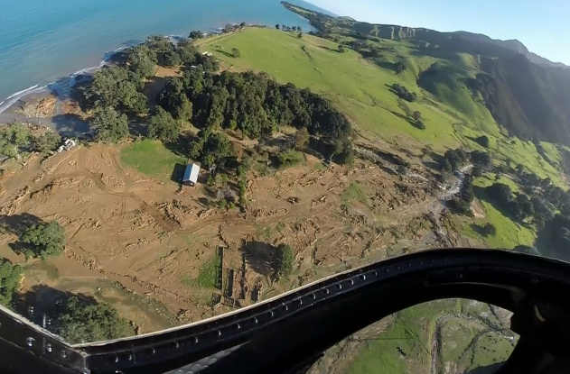
Auckland/Hamilton Aerial Photography
Archive of twenty-thousand aerial photographs captured at an altitude of one-hundred feet above sea level, together with corresponding port and starboard images offset at an angle of approximately 30o...
N/A
Creative Commons Attribution 4.0 International
Sentinel Satellite snapshot of Waikato region
Spanning the period 2014 through 2020, focusing on the Lake Whangape area within the Waikato region of New Zealand, images captured by the satellites; Sentinel 1 and Sentinel 2. Sentinel 1 captures im...
-
Creative Commons Attribution 4.0 International
Tropical Cyclone Archive
Archive of tropical cyclone trajectory aggregated from multiple providers.
Unknown
Creative Commons Attribution 4.0 International
Google Earth Data Catalog
A multi-petabyte catalog of planetary scale satellite imagery and associated data products. Data sets are categorised into: Climate & Weather, Imagery, and Geophysical and include climate, weather, s...
Creative Commons Attribution 4.0 International
NZ Rain Radar raw archive Metservice automatic weather stations
This includes an archive of data from the MetService dopple radar network.
MetService
Kaitiakitanga License, Creative Commons Attribution-NonCommercial 4.0 International
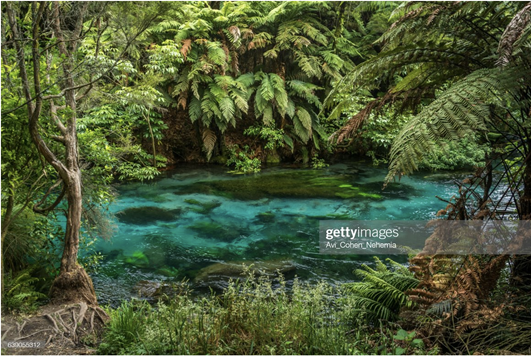
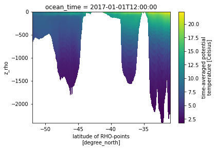
Moana hydrodynamic hindcast
The Moana backbone hindcast datasets comes in the form of 4 sources of data stored in 4 subfolders on the thredds server. 25 hydrodynamic hindcast of New Zealands water generated as part of the NZ MBI...
Meteorological Service of New Zealand Ltd
Creative Commons Attribution-NoDerivatives 4.0 International, Creative Commons Attribution 4.0 International, Kaitiakitanga License
Metservice automatic weather stations
Data collected from an array of fixed weather stations located across the country. Haast automatic weather station: 4-8kfysg Ardmore airport automatic weather station: 4-8kfysg Ashburton Aerodrome au...
MetService
Creative Commons Attribution-NoDerivatives 4.0 International, Creative Commons Attribution-NonCommercial-NoDerivatives 4.0 International
Global Topography
Topography measurement covering the entire surface of the globe. Data captured from the satellite includes: Topography metrics; ARD tile format. Extracted from the NASA Making Earth System Data Recor...
Global Land Analysis and Discovery Team, University of Maryland
Creative Commons Attribution 4.0 International
Mt Karioi Predator Videos
This data set encompasses more than two-thousand one hundred, thirty-second video clips captured using Infra-red triggered Bushnell cameras. The cameras are distributed through thirty locations within...
Waikato Regional Council / Karioi Project
Creative Commons Attribution 4.0 International
Landsat 8 - Remote Sensing Data
Global analysis ready multispectral satellite data from Landsat 8 OLI sensor. Landsat 8 provides the capability to capture data medium resolution image data covering the global landmass.
N/A
Creative Commons Attribution 4.0 International
Critter Detector
Below is a video from a camera trap set in New Zealand for which we wish to detect the species of critter in the video.
None
Test Notebook
Test
Creative Commons Attribution-NonCommercial-NoDerivatives 4.0 International, Creative Commons Attribution-ShareAlike 4.0 International, MIT
Coasts and Ocean Collective database
Here we provide four time-slices of high resolution (9 km) wave climate data for the New Zealand waters. We developed a set of historical and projected (1993–2006, 2026–2046, 2080–2100) wave climatolo...
None

Moana thredds server connector
This notebook describes how to get observation data from the thredds server set on top of the Moana 25 year hydrodynamic hindcast of New Zealand waters. The data is freely available from that server u...
Kaitiakitanga License, Creative Commons Attribution-ShareAlike 4.0 International
NZ Metservice Rain Radar Network
This notebook describes how to work with the raw radar files produced by the MetServices rain radar network. It shows how to read them and interact with the key quantities to plot the data. The last p...
None

NZ radar raw data connector
This notebook describes how to work with the raw radar files produced by the MetServices rain radar network. It shows how to read them and interact with the key quantities to plot the data. The last p...
Creative Commons Attribution-ShareAlike 4.0 International, GNU GPLv3
Taiao Case 4
-
None
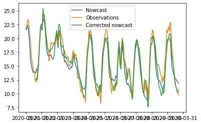
MetOcean Solutions Observation API connector
This notebook describes how to get observation data from one of MetOcean Solutions' observation API. The data that can be accessed though the API come from different sources such as MetService's auto...
Creative Commons Attribution 4.0 International, Creative Commons Attribution-ShareAlike 4.0 International, GNU GPLv3
MOA is the most popular open source framework for data stream mining, with a very active growing community (blog).
An example of Explainable Machine Learning can be found here.
WEKA (Waikato Environment for Knowledge Analysis) is an open source machine learning software in JAVA. It contains tools for data preparation, classification, regression, clustering, association rules mining, and visualization.
A Python package for online/streaming machine learning.
The Advanced Data mining And Machine learning System (ADAMS) is a flexible workflow engine aimed at quickly building and maintaining data-driven, reactive workflows, easily integrated into business processes, released under GPLv3.
Prediction of coastal flooding events within New Zealand. Important to have some capability to describe the event, and its impact on the environment. An area of particular concern is the estimation of bathymetry data for estuaries.
Machine learning in Python
This instructional material will provide an introductory guide to Jupyter Notebooks and the Python programming language.
An Introduction
A library for data stream mining